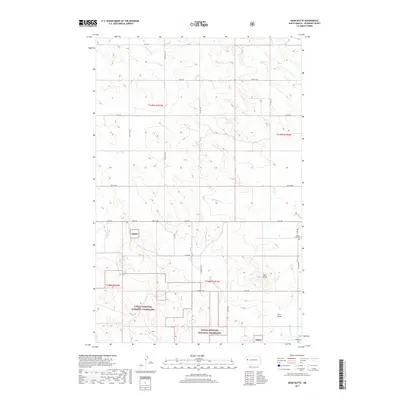
2017 Map of Bear Butte
USGS Topo · Published 2017About this map
Little Missouri National Grassland dominates the southern landscape of this McKenzie County region, where the badlands topography transitions into more regular surveying grids. The distinctive rise of Bear Butte serves as a primary landmark in the southeast, situated near Docs Draw and the winding course of Red Wing Cr. Local heritage is anchored by the presence of Spring Grove Cem and Red Wing Cem, which provide specific points of interest for genealogical research in this sparsely populated area. The map reveals a disciplined network of section lines and gravel roads, such as Co Rd 30 and 140th Ave NW, which negotiate the drainage systems of Antelope Cr and Cherry Cr. This configuration of land management and natural drainage reflects the early 21st-century agricultural and conservation patterns of western North Dakota.
Find a feature on this map
32 named features on this map. Tap any name to fly to it.
Don’t see what you’re looking for? This feature index may not catch every label — zoom into the map to look around manually.
Map Details
Editions of this 2017 Bear Butte Map
This is the sole edition of this map. No revisions or reprints were ever made.
Other maps of this area

1953 · Watford City
USGS Topo · 1:250,000

1957 · Watford City
USGS Topo · 1:250,000

1958 · Sperati Point
USGS Topo · 1:24,000

1958 · Stocke Butte
USGS Topo · 1:24,000

1967 · Watford City
USGS Topo · 1:250,000

1972 · Bear Butte
USGS Topo · 1:24,000

1972 · Alexander
USGS Topo · 1:24,000

1972 · Moline School
USGS Topo · 1:24,000

1972 · Rawson
USGS Topo · 1:24,000
1972 · Burning Mine Butte
USGS Topo · 1:24,000