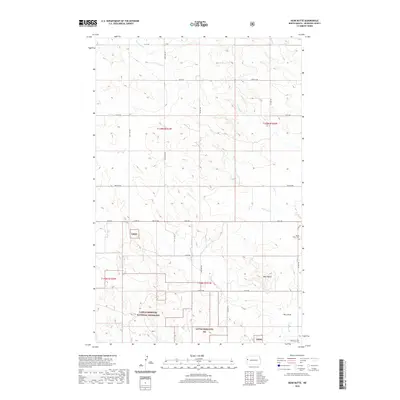
2020 Map of Bear Butte
USGS Topo · Published 2020About this map
Little Missouri National Grassland dominates this landscape in McKenzie County, showing a vast expanse of public land defined by drainage patterns and distinct buttes. The terrain is marked by intermittent watercourses like Antelope Cr and Cherry Cr which carve through the high plains toward the Red Wing Cr. Local heritage is anchored by two quiet landmarks: Spring Grove Cem in the northeast and Red Wing Cem to the southeast, serving as markers of the rural community's footprint. The namesake Bear Butte rises as a prominent landmark above Docs Draw, illustrating the classic topography of the North Dakota badlands region. The map also delineates the precise township and range boundaries, such as t148n r101w, which organize the grid of section lines and secondary roads like Co Rd 30.
Find a feature on this map
32 named features on this map. Tap any name to fly to it.
Don’t see what you’re looking for? This feature index may not catch every label — zoom into the map to look around manually.
Map Details
Editions of this 2020 Bear Butte Map
This is the sole edition of this map. No revisions or reprints were ever made.
Other maps of this area

1953 · Watford City
USGS Topo · 1:250,000

1957 · Watford City
USGS Topo · 1:250,000

1958 · Sperati Point
USGS Topo · 1:24,000

1958 · Stocke Butte
USGS Topo · 1:24,000

1967 · Watford City
USGS Topo · 1:250,000

1972 · Bear Butte
USGS Topo · 1:24,000

1972 · Alexander
USGS Topo · 1:24,000

1972 · Moline School
USGS Topo · 1:24,000

1972 · Rawson
USGS Topo · 1:24,000
1972 · Burning Mine Butte
USGS Topo · 1:24,000