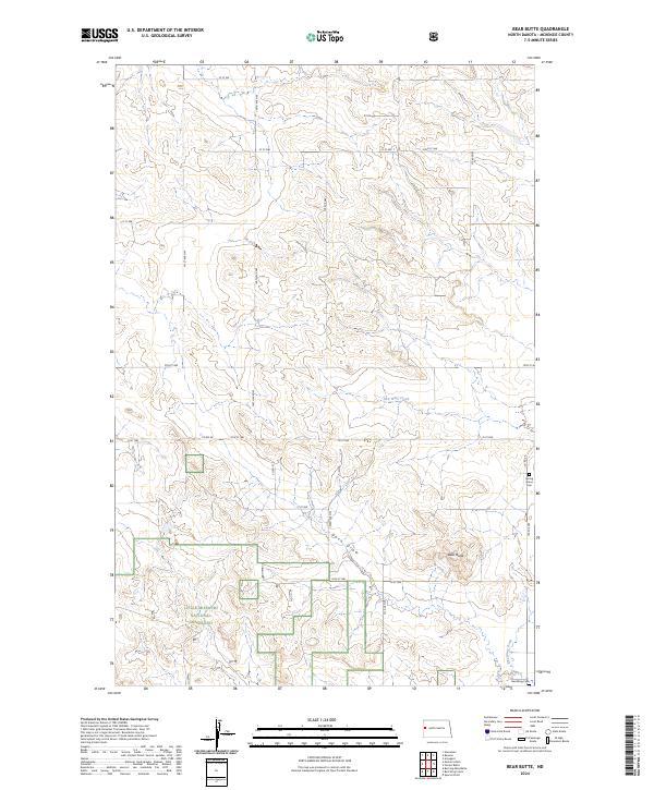
2024 Map of Bear Butte
USGS Topo · Published 2024About this map
Little Missouri National Grassland dominates the southwestern corner of this landscape, where the broken terrain of McKenzie County transitions into the drainage of Red Wing Creek. The map reveal a sparsely populated cattle-country geography defined by isolated landmarks and small rural burial sites such as Spring Grove Cem and Red Wing Cem. At the center of the eastern half, the prominent rise of Bear Butte stands over the head of Docs Draw, serving as a primary navigational point for the surrounding township sections. The road network, largely composed of section-line routes like 140th Ave NW and 18th St NW, reflects the rigid grid of the Public Land Survey System applied over an uneven, coulee-cut topography.
Find a feature on this map
29 named features on this map. Tap any name to fly to it.
Don’t see what you’re looking for? This feature index may not catch every label — zoom into the map to look around manually.
Map Details
Editions of this 2024 Bear Butte Map
This is the sole edition of this map. No revisions or reprints were ever made.
Other maps of this area

1953 · Watford City
USGS Topo · 1:250,000

1957 · Watford City
USGS Topo · 1:250,000

1958 · Sperati Point
USGS Topo · 1:24,000

1958 · Stocke Butte
USGS Topo · 1:24,000

1967 · Watford City
USGS Topo · 1:250,000

1972 · Bear Butte
USGS Topo · 1:24,000

1972 · Alexander
USGS Topo · 1:24,000

1972 · Moline School
USGS Topo · 1:24,000

1972 · Rawson
USGS Topo · 1:24,000
1972 · Burning Mine Butte
USGS Topo · 1:24,000