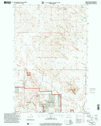
1997 Map of Bear Butte
USGS Topo · Published 2000About this map
Little Missouri National Grassland dominates the southern reaches of this McKenzie County landscape, where the broken terrain of the North Dakota badlands gives way to drainages and isolated high points. The map prominently features Bear Butte, a local landmark standing above the intersection of numerous seasonal waterways including Dogs Draw and the winding Red Wing Creek. The Twelfth Standard Parallel North serves as a major cartographic divider, splitting the township grids of this rural expanse. Genealogists and local historians can locate the Spring Grove Cem in the northeast and Red Wing Cem to the south. These markers, alongside scattered Gravel Pit sites and remote ranch tracks, illustrate the sparse settlement pattern and resource-based land use in the region during the late twentieth century.
Find a feature on this map
14 named features on this map. Tap any name to fly to it.
Don’t see what you’re looking for? This feature index may not catch every label — zoom into the map to look around manually.
Map Details
Editions of this 1997 Bear Butte Map
This is the sole edition of this map. No revisions or reprints were ever made.
Other maps of this area

1953 · Watford City
USGS Topo · 1:250,000

1957 · Watford City
USGS Topo · 1:250,000

1958 · Sperati Point
USGS Topo · 1:24,000

1958 · Stocke Butte
USGS Topo · 1:24,000

1967 · Watford City
USGS Topo · 1:250,000

1972 · Bear Butte
USGS Topo · 1:24,000

1972 · Alexander
USGS Topo · 1:24,000

1972 · Moline School
USGS Topo · 1:24,000

1972 · Rawson
USGS Topo · 1:24,000
1972 · Burning Mine Butte
USGS Topo · 1:24,000