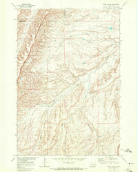
1968 Map of Bear Coulee
USGS Topo · Published 1972About this map
The Crow Indian Reservation landscape is defined by the prominent Wild Horse Ridge, which serves as a major geographical spine through this portion of Big Horn and Yellowstone counties. Surveyed in 1968, the terrain is deeply incised by a network of drainages that support the seasonal ecology of the region. Significant watercourses including Woody Creek, Beauvais Creek, and the eponymous Bear Coulee snake through the breaks, illustrating the complex erosion patterns typical of the Montana plains. This area is largely characterized by its lack of established towns, instead showing a vast network of fence lines and remote landmarks such as Scott Creek and Horse Coulee. The map provides a detailed study of land use within the reservation during the late 1960s, capturing the relationship between high ridges and the winding creek beds like Buster Creek and Push Creek that define the local topography.
Find a feature on this map
14 named features on this map. Tap any name to fly to it.
Don’t see what you’re looking for? This feature index may not catch every label — zoom into the map to look around manually.
Map Details
Editions of this 1968 Bear Coulee Map
2 editions found
Other maps of this area

1893 · Huntley
USGS Topo · 1:125,000

1954 · Billings
USGS Topo · 1:250,000

1957 · Billings
USGS Topo · 1:250,000

1958 · Billings
USGS Topo · 1:250,000
1964 · Horse Coulee
USGS Topo · 1:24,000
1964 · Grapevine Dome
USGS Topo · 1:24,000

1967 · Deep Creek SE
USGS Topo · 1:24,000

1967 · Soda Springs
USGS Topo · 1:24,000
1967 · Chilkoot Coulee
USGS Topo · 1:24,000
1969 · Mott Creek
USGS Topo · 1:24,000