
1970 Map of Bear Creek
USGS Topo · Published 1973About this map
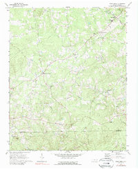
Bear Creek serves as a central hub for this rural landscape in central North Carolina, situated along the Southern railway line. The map captures a transitional rural economy where active industry like the Quarry south of the Chatham Co Moore Co line exists alongside an extensive network of country churches such as Antioch Ch and Tysons Creek Ch.
Find a feature on this map
28 named features on this map. Tap any name to fly to it.
Don’t see what you’re looking for? This feature index may not catch every label — zoom into the map to look around manually.
Map Details
Editions of this 1970 Bear Creek Map
2 editions found
Other maps of this area

1942 · Troy
USGS Topo · 1:125,000

1953 · Raleigh
USGS Topo · 1:250,000

1954 · Raleigh
USGS Topo · 1:250,000

1968 · Coleridge
USGS Topo · 1:24,000

1968 · Bennett
USGS Topo · 1:24,000

1969 · Siler City
USGS Topo · 1:24,000

1970 · Goldston
USGS Topo · 1:24,000

1970 · Siler City NE
USGS Topo · 1:24,000

1974 · White Hill
USGS Topo · 1:24,000

1974 · Putnam
USGS Topo · 1:24,000