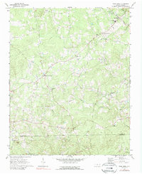
1970 Map of Bear Creek
USGS Topo · Published 1989About this map
Bear Creek serves as the focal point for this rural landscape in the 1970s, where the Southern railroad line intersects with local life near Chatham Central High Sch. The region is defined by a dense network of small communities and rural congregations, including Antioch Ch, Tysons Creek Ch, and Providence Ch. These landmarks, often accompanied by local cemeteries, offer significant genealogical clues for families tracing roots in the area surrounding Harpers Crossroads and Johnsons Crossing.
Find a feature on this map
26 named features on this map. Tap any name to fly to it.
Don’t see what you’re looking for? This feature index may not catch every label — zoom into the map to look around manually.
Map Details
Editions of this 1970 Bear Creek Map
2 editions found
Other maps of this area

1942 · Troy
USGS Topo · 1:125,000

1953 · Raleigh
USGS Topo · 1:250,000

1954 · Raleigh
USGS Topo · 1:250,000

1968 · Coleridge
USGS Topo · 1:24,000

1968 · Bennett
USGS Topo · 1:24,000

1969 · Siler City
USGS Topo · 1:24,000

1970 · Goldston
USGS Topo · 1:24,000

1970 · Bear Creek
USGS Topo · 1:24,000

1970 · Siler City NE
USGS Topo · 1:24,000

1974 · White Hill
USGS Topo · 1:24,000