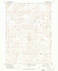
1971 Map of Bear Hill
USGS Topo · Published 1973About this map
Bear Hill rises as a prominent landmark in this western Nebraska landscape, situated along the boundary of Arthur Co and Keith Co. The area is characterized by a network of isolated homesteads and ranching operations, including McKeag Ranch and Beeken Ranch, which are connected by a series of unimproved roads and fence lines. This 1970s survey captures the region's ranching economy, where water management is central to life, evidenced by several wells and a notable Spring located near the northern edge of the quadrangle.
Find a feature on this map
14 named features on this map. Tap any name to fly to it.
Don’t see what you’re looking for? This feature index may not catch every label — zoom into the map to look around manually.
Map Details
Editions of this 1971 Bear Hill Map
This is the sole edition of this map. No revisions or reprints were ever made.
Other maps of this area

1897 · Ogallala
USGS Topo · 1:125,000

1900 · Ogallala
USGS Topo · 1:125,000

1949 · Arthur
USGS Topo · 1:62,500

1950 · Velma
USGS Topo · 1:62,500

1950 · Arthur
USGS Topo · 1:62,500

1954 · North Platte
USGS Topo · 1:250,000

1956 · North Platte
USGS Topo · 1:250,000

1957 · North Platte
USGS Topo · 1:250,000

1967 · North Platte
USGS Topo · 1:250,000

1971 · Martin
USGS Topo · 1:24,000