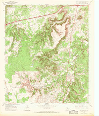
1966 Map of Bear Mountain
USGS Topo · Published 1969About this map
Bear Mountain dominates the northeast corner of this 1960s survey, rising above a landscape defined by deeply incised drainage systems and mid-century industrial development. The terrain is carved by the Bear Creek, Jenny Creek, and the complex forks of Pinto Creek, creating a rugged topography that shaped the local transport and extraction patterns. Evidence of the area's changing economy is visible through the Old Railroad Grade cutting across the southwestern quadrant, a remnant of earlier freight needs now bypassed by modern Pipelines. This era of the Eastland County landscape is further marked by the expansion of the energy sector, with numerous Oil Wells and a Drill Hole scattered throughout the canyon lands, alongside localized excavations like a Quarry and Gravel Pit.
Find a feature on this map
15 named features on this map. Tap any name to fly to it.
Don’t see what you’re looking for? This feature index may not catch every label — zoom into the map to look around manually.
Map Details
Editions of this 1966 Bear Mountain Map
2 editions found
Other maps of this area

1890 · Stephenville
USGS Topo · 1:125,000

1890 · Breckenridge
USGS Topo · 1:125,000

1891 · Palo Pinto
USGS Topo · 1:125,000

1894 · Eastland
USGS Topo · 1:125,000

1918 · Palo Pinto
USGS Topo · 1:125,000

1920 · Stephenville
USGS Topo · 1:125,000

1954 · Abilene
USGS Topo · 1:250,000

1958 · Abilene
USGS Topo · 1:250,000

1959 · Gordon
USGS Topo · 1:62,500

1965 · Huckabay SW
USGS Topo · 1:24,000