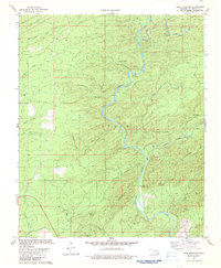
1982 Map of Bear Mountain
USGS Topo · Published 1983About this map
The Glover River carves a deep, winding path through this corner of McCurtain County, defining a landscape of narrow hollows and prominent summits. The 1982 survey captures the area during a period of active timber and land management, centered around Dierks Camp and the small settlement of Alikchi. High points such as Bear Mountain, which features a prominent Lookout Tower, and Chinquapin Mountain overlook a complex drainage system including North Cedar Creek and Horse Head Creek. Numerous named hollows like Black Sulphur Hollow and Meat Hollow reveal the intricate topography of the terrain. The presence of a Gravel Pit and established camps among the springs, including Burks Springs and Cold Springs, illustrates the local intersection of natural resources and early industrial activity in the Oklahoma backcountry.
Find a feature on this map
34 named features on this map. Tap any name to fly to it.
Don’t see what you’re looking for? This feature index may not catch every label — zoom into the map to look around manually.
Map Details
Editions of this 1982 Bear Mountain Map
This is the sole edition of this map. No revisions or reprints were ever made.
Other maps of this area

1901 · Alikchi
USGS Topo · 1:125,000

1902 · Lukfata
USGS Topo · 1:125,000

1950 · Mcalester
USGS Topo · 1:250,000

1959 · Golden
USGS Topo · 1:62,500

1960 · Bethel
USGS Topo · 1:62,500

1962 · McAlester
USGS Topo · 1:250,000

1962 · Wright City
USGS Topo · 1:24,000

1962 · Alikchi
USGS Topo · 1:24,000

1962 · Signal Mountain
USGS Topo · 1:24,000

1965 · McAlester
USGS Topo · 1:250,000