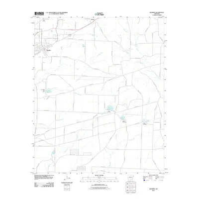
2011 Map of Bearden
USGS Topo · Published 2011About this map
The town of Bearden serves as the primary hub in this corner of Ouachita County, showing a detailed street grid including Gatling Ave and N Plum St. The surrounding landscape is defined by a dense network of waterways and managed water features, most notably a series of dammed enclosures such as North Pond, Middle Pond, and South Pond situated along Locust Bayou. These features, along with Covington Pond, suggest a history of local water management or industrial use within the drainage basins of Two Bayou and Joe Jack Creek.
Find a feature on this map
79 named features on this map. Tap any name to fly to it.
Don’t see what you’re looking for? This feature index may not catch every label — zoom into the map to look around manually.
Map Details
Editions of this 2011 Bearden Map
This is the sole edition of this map. No revisions or reprints were ever made.
Other maps of this area

1903 · Camden
USGS Topo · 1:125,000

1953 · El Dorado
USGS Topo · 1:250,000

1957 · El Dorado
USGS Topo · 1:250,000

1958 · El Dorado
USGS Topo · 1:250,000

1960 · El Dorado
USGS Topo · 1:250,000

1966 · Fordyce
USGS Topo · 1:24,000

1973 · Bearden
USGS Topo · 1:24,000
1973 · Eagle Mills
USGS Topo · 1:24,000
1973 · Holly Springs
USGS Topo · 1:24,000
1973 · East Camden
USGS Topo · 1:24,000