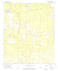
1973 Map of East Camden
USGS Topo · Published 1975About this map
The Abandoned Ammunition Depot dominates the northeastern landscape of this mid-1970s survey, a large-scale military installation situated east of Dogwood. The terrain transitions from the developed community of East Camden, featuring a Golf Course and several parks, into the wetlands and bayous characteristic of the Ouachita and Calhoun county line. The map captures a rural economy defined by resource extraction, from the Locust Bayou Oil Field to numerous Gravel Pits and sandpits scattered near Two Bayou.
Find a feature on this map
27 named features on this map. Tap any name to fly to it.
Don’t see what you’re looking for? This feature index may not catch every label — zoom into the map to look around manually.
Map Details
Editions of this 1973 East Camden Map
2 editions found
Other maps of this area

1903 · Camden
USGS Topo · 1:125,000

1951 · Camden
USGS Topo · 1:24,000

1953 · El Dorado
USGS Topo · 1:250,000

1957 · El Dorado
USGS Topo · 1:250,000

1958 · El Dorado
USGS Topo · 1:250,000

1960 · El Dorado
USGS Topo · 1:250,000

1962 · Louann
USGS Topo · 1:24,000

1962 · Smackover NE
USGS Topo · 1:24,000

1962 · Snow Hill
USGS Topo · 1:24,000

1964 · Smackover
USGS Topo · 1:62,500