
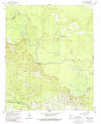
1962 Map of Snow Hill
USGS Topo · Published 1963About this map
The Ouachita River meanders through this landscape, creating a series of oxbows and cutoffs such as Half Moon Lake and Spoon Lake. This 1962 topography illustrates a transition between the river's winding bottomlands and the industrial activity of the southern reaches. In the lower portion of the map, the Smackover Oil and Gas Field dominates the terrain, with a dense network of roads and structures supporting the local extraction industry near Snow Hill and Joyce City.
Find a feature on this map
26 named features on this map. Tap any name to fly to it.
Don’t see what you’re looking for? This feature index may not catch every label — zoom into the map to look around manually.
Map Details
Editions of this 1962 Snow Hill Map
3 editions found

Other maps of this area

1903 · Camden
USGS Topo · 1:125,000

1951 · Camden
USGS Topo · 1:24,000

1953 · El Dorado
USGS Topo · 1:250,000

1957 · El Dorado
USGS Topo · 1:250,000

1958 · El Dorado
USGS Topo · 1:250,000

1960 · El Dorado
USGS Topo · 1:250,000

1962 · Lisbon
USGS Topo · 1:24,000

1962 · Louann
USGS Topo · 1:24,000

1962 · Smackover NE
USGS Topo · 1:24,000

1962 · Smackover
USGS Topo · 1:24,000