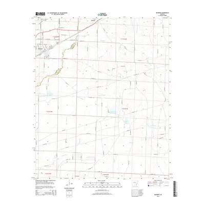
2014 Map of Bearden
USGS Topo · Published 2014About this map
Bearden serves as the primary residential and commercial anchor in this south-central Arkansas landscape, situated along the Us-79 corridor and its business route, Bus 79. The town's grid of streets transitions into a network of timbered lowlands and creek bottoms that define the border between Ouachita and Calhoun counties. To the north, the small settlement of Harlow is centered around the Harlow Cemetery, while the northernmost reaches include Moss Cemetery and Moss Hill Cemetery, providing significant points of interest for genealogical research in this rural pocket.
Find a feature on this map
100 named features on this map. Tap any name to fly to it.
Don’t see what you’re looking for? This feature index may not catch every label — zoom into the map to look around manually.
Map Details
Editions of this 2014 Bearden Map
This is the sole edition of this map. No revisions or reprints were ever made.
Other maps of this area

1903 · Camden
USGS Topo · 1:125,000

1953 · El Dorado
USGS Topo · 1:250,000

1957 · El Dorado
USGS Topo · 1:250,000

1958 · El Dorado
USGS Topo · 1:250,000

1960 · El Dorado
USGS Topo · 1:250,000

1966 · Fordyce
USGS Topo · 1:24,000

1973 · Bearden
USGS Topo · 1:24,000
1973 · Eagle Mills
USGS Topo · 1:24,000
1973 · Holly Springs
USGS Topo · 1:24,000
1973 · East Camden
USGS Topo · 1:24,000