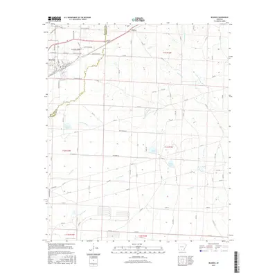
2017 Map of Bearden
USGS Topo · Published 2017About this map
Bearden and the small settlement of Harlow anchor this landscape along the border of Ouachita and Calhoun counties. The terrain is defined by a complex drainage network where Locust Bayou and Two Bayou wind through the timberlands, feeding into numerous named wetlands such as Covington Pond, North Pond, and Middle Pond. This 2017 survey reflects the modern road system, including Ouachita Road 280 and Co Rd 70, which connect the rural homesteads and family sites. Genealogists will find the locations of Moss Cem and Harlow Cem particularly useful for identifying family burials in this corner of Arkansas. The survey captures the intricate balance between the local water systems like Little Champagnolle Cr and the rural infrastructure that has supported these communities into the 21st century.
Find a feature on this map
94 named features on this map. Tap any name to fly to it.
Don’t see what you’re looking for? This feature index may not catch every label — zoom into the map to look around manually.
Map Details
Editions of this 2017 Bearden Map
This is the sole edition of this map. No revisions or reprints were ever made.
Other maps of this area

1903 · Camden
USGS Topo · 1:125,000

1953 · El Dorado
USGS Topo · 1:250,000

1957 · El Dorado
USGS Topo · 1:250,000

1958 · El Dorado
USGS Topo · 1:250,000

1960 · El Dorado
USGS Topo · 1:250,000

1966 · Fordyce
USGS Topo · 1:24,000

1973 · Bearden
USGS Topo · 1:24,000
1973 · Eagle Mills
USGS Topo · 1:24,000
1973 · Holly Springs
USGS Topo · 1:24,000
1973 · East Camden
USGS Topo · 1:24,000