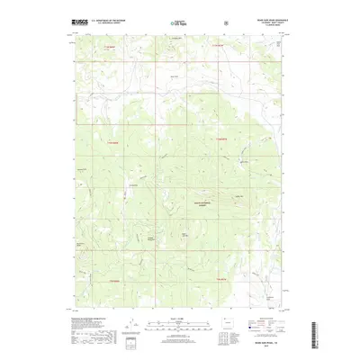
2019 Map of Bears Ears Peaks
USGS Topo · Published 2019About this map
Bears Ears Peaks and the high Elkhead Mountains dominate this landscape within the Routt National Forest. The geography is defined by a series of high-elevation parks, which in this region refer to open mountain basins rather than manicured recreation areas. These include Slater Park, Grizzly Park, Adams Park, and California Park, each serving as a collection point for the numerous headwater streams that carve through the timbered slopes. Notable summits such as Columbus Mtn, Sawtooth Mtn, and Sugar Loaf Mtn provide significant vertical relief above the drainage networks of Elkhead Creek and Slater Creek. The map shows a transition from these sheltered basins to the prominent ridges of the continental divide area, highlighting the intricate hydrology of Hole-in-the-Wall Creek and the remote Cold Spring.
Find a feature on this map
40 named features on this map. Tap any name to fly to it.
Don’t see what you’re looking for? This feature index may not catch every label — zoom into the map to look around manually.
Map Details
Editions of this 2019 Bears Ears Peaks Map
This is the sole edition of this map. No revisions or reprints were ever made.
Other maps of this area

1923 · Elkhead Creek
USGS Topo · 1:62,500

1923 · Pilot Knob
USGS Topo · 1:62,500

1924 · Elkhead Creek
USGS Topo · 1:62,500

1925 · Pilot Knob
USGS Topo · 1:62,500

1954 · Craig
USGS Topo · 1:250,000

1957 · Craig
USGS Topo · 1:250,000

1958 · Craig
USGS Topo · 1:250,000

1960 · Craig
USGS Topo · 1:250,000

1962 · Craig
USGS Topo · 1:250,000
1962 · Tumble Mountain
USGS Topo · 1:24,000