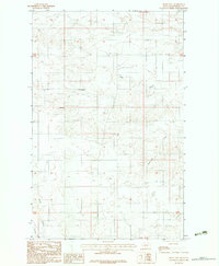
1983 Map of Bears Nest
USGS Topo · Published 1983About this map
Bears Nest rises above a landscape defined by its seasonal waterways and high plains drainage in this northeast Montana quadrangle. The area showcases a transition between the northern high ground and the branching system of Sage Creek and Assiniboine Creek that moves through the eastern sections. Human presence is sparse, marked primarily by the land-division grid and localized water sources like Snell Spring, which would have been vital for cattle and early ranching operations in this part of Roosevelt County.
Find a feature on this map
9 named features on this map. Tap any name to fly to it.
Don’t see what you’re looking for? This feature index may not catch every label — zoom into the map to look around manually.
Map Details
Editions of this 1983 Bears Nest Map
2 editions found
Other maps of this area

1910 · Cuskers
USGS Topo · 1:62,500

1915 · Tule Valley
USGS Topo · 1:62,500

1915 · Cuskers
USGS Topo · 1:62,500

1954 · Wolf Point
USGS Topo · 1:250,000

1958 · Wolf Point
USGS Topo · 1:250,000

1973 · Bredette
USGS Topo · 1:24,000

1973 · Nielsen Coulee
USGS Topo · 1:24,000

1973 · Peerless 4 SE
USGS Topo · 1:24,000
1983 · Tule Valley East
USGS Topo · 1:24,000
1983 · Long Creek West
USGS Topo · 1:24,000