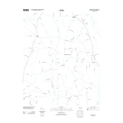
2013 Map of Bearskin
USGS Topo · Published 2013About this map
Bearskin and its surrounding crossroads communities define this landscape of Sampson County, where agriculture and hydrology dictate the pattern of settlement. Named crossroads such as Beaman Crossroads, Reynolds Crossroads, and Kitty Fork serve as focal points for rural commerce and social organization, connected by a dense web of local roads including Reindeer Ln and Tyndall Bridge Rd. The terrain is characterized by an extensive system of low-lying waterways, most notably the winding corridors of Bearskin Swamp, White Oak Swamp, and Hornet Swamp. These wetlands, along with Great Coharie Cr and smaller bodies like Halls Pond and Laurel Lake, illustrate the historical importance of drainage and water management in North Carolina's coastal plain. The distribution of family-named roads like Crumpler Mill Rd and Strickland Cabin Ln provides valuable insights for local genealogists tracing the legacy of rural land ownership in the early 21st century.
Find a feature on this map
105 named features on this map. Tap any name to fly to it.
Don’t see what you’re looking for? This feature index may not catch every label — zoom into the map to look around manually.
Map Details
Editions of this 2013 Bearskin Map
This is the sole edition of this map. No revisions or reprints were ever made.
Other maps of this area

1909 · Coharie
USGS Topo · 1:62,500

1953 · Florence
USGS Topo · 1:250,000

1953 · Raleigh
USGS Topo · 1:250,000

1954 · Florence
USGS Topo · 1:250,000

1954 · Raleigh
USGS Topo · 1:250,000

1959 · Roseboro
USGS Topo · 1:62,500

1959 · Garland
USGS Topo · 1:62,500

1974 · Salemburg
USGS Topo · 1:24,000
1974 · Mingo
USGS Topo · 1:24,000

1982 · Elizabethtown
USGS Topo · 1:100,000