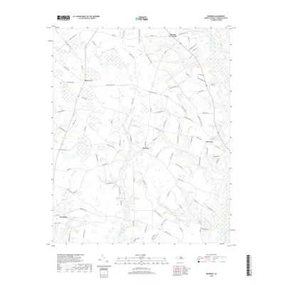
2019 Map of Bearskin
USGS Topo · Published 2019About this map
Salemburg sits at the southwestern edge of this coastal plain landscape, characterized by an intricate network of sluggish waterways and wetlands. The drainage pattern is defined by the Great Coharie Creek and several substantial swamp systems including Old-Mill Swamp, Bearskin Swamp, and White Oak Swamp. These low-lying areas historically dictated the placement of roads and small communities like Bearskin, Beaman Crossroads, and Kitty Fork, which occupy the slightly higher ground between the wetlands. The presence of Halls Pond and Laurel Lake further illustrates the hydrological character of Sampson County. In the north, Piney Green and Marsh Swamp show the persistence of traditional rural settlement patterns where family farm roads like Henry Vann Farm Rd and Roy Jones Ln branch off from established thoroughfares.
Find a feature on this map
95 named features on this map. Tap any name to fly to it.
Don’t see what you’re looking for? This feature index may not catch every label — zoom into the map to look around manually.
Map Details
Editions of this 2019 Bearskin Map
This is the sole edition of this map. No revisions or reprints were ever made.
Other maps of this area

1909 · Coharie
USGS Topo · 1:62,500

1953 · Florence
USGS Topo · 1:250,000

1953 · Raleigh
USGS Topo · 1:250,000

1954 · Florence
USGS Topo · 1:250,000

1954 · Raleigh
USGS Topo · 1:250,000

1959 · Roseboro
USGS Topo · 1:62,500

1959 · Garland
USGS Topo · 1:62,500

1974 · Salemburg
USGS Topo · 1:24,000
1974 · Mingo
USGS Topo · 1:24,000

1982 · Elizabethtown
USGS Topo · 1:100,000