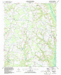
1986 Map of Bearskin
USGS Topo · Published 1986About this map
Beaman Crossroads and Reynolds Crossroads anchor the rural landscape of central Sampson County in the mid-1980s, a region defined by an intricate network of agricultural clearings and swampy drainage basins. The area’s spiritual and communal life is mapped through numerous country churches, including Sampson Chapel, Freedom Ch, and Mt Pleasant Ch, many of which sit adjacent to small family cemeteries.
Find a feature on this map
37 named features on this map. Tap any name to fly to it.
Don’t see what you’re looking for? This feature index may not catch every label — zoom into the map to look around manually.
Map Details
Editions of this 1986 Bearskin Map
This is the sole edition of this map. No revisions or reprints were ever made.
Other maps of this area

1909 · Coharie
USGS Topo · 1:62,500

1953 · Florence
USGS Topo · 1:250,000

1953 · Raleigh
USGS Topo · 1:250,000

1954 · Florence
USGS Topo · 1:250,000

1954 · Raleigh
USGS Topo · 1:250,000

1959 · Roseboro
USGS Topo · 1:62,500

1959 · Garland
USGS Topo · 1:62,500

1974 · Salemburg
USGS Topo · 1:24,000
1974 · Mingo
USGS Topo · 1:24,000

1982 · Elizabethtown
USGS Topo · 1:100,000