
1963 Map of Bearwallow Mountain
USGS Topo · Published 1965About this map
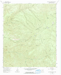
Bearwallow Mountain dominates this high-elevation portion of the Mogollon Mountains, a landscape defined by sharp drainages and scattered outposts within the Gila National Forest. In the early 1960s, the terrain was navigated primarily via a system of pack trails and jeep tracks, such as the Pack Trail winding through Dark Canyon and the path leading to the Lookout Tower atop the summit. Evidence of human presence is sparse but specific, with the Old Waterman Place and a Trailer Cabin marking small clearances in the dense network of canyons. The map tracks numerous water sources vital for forest management and ranching, including Lost Lake, Turkey Spring, and the Turkey Cienega. From Cooney Peak to the deep cut of Mineral Creek, the topography reveals the isolation and verticality of this southwestern New Mexico wilderness.
Find a feature on this map
43 named features on this map. Tap any name to fly to it.
Don’t see what you’re looking for? This feature index may not catch every label — zoom into the map to look around manually.
Map Details
Editions of this 1963 Bearwallow Mountain Map
2 editions found
Other maps of this area

1910 · Mogollon
USGS Topo · 1:125,000

1912 · Mogollon
USGS Topo · 1:125,000

1915 · Reserve
USGS Topo · 1:125,000

1918 · Reserve
USGS Topo · 1:125,000

1954 · Clifton
USGS Topo · 1:250,000

1957 · Clifton
USGS Topo · 1:250,000

1958 · Clifton
USGS Topo · 1:250,000

1962 · Clifton
USGS Topo · 1:250,000

1963 · Negrito Mountain
USGS Topo · 1:24,000
1963 · Sign Camp Mountain
USGS Topo · 1:24,000