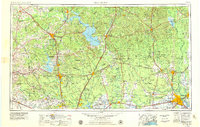
1954 Map of Beaumont
USGS Topo · Published 1979About this map
Big Thicket National Preserve and the massive Sam Houston National Forest dominate this landscape, illustrating the dense piney woods of Southeast Texas during the mid-1970s revision. The map captures a region defined by its timber and river systems, showing the recently completed reservoirs of Lake Livingston and Lake Conroe which transformed the hydrology of the Trinity River and San Jacinto River basins. In the west, Huntsville appears as a major institutional hub, surrounded by several agricultural detention centers including Ferguson State Prison Farm and Wynne State Prison Farm.
Find a feature on this map
187 named features on this map. Tap any name to fly to it.
Don’t see what you’re looking for? This feature index may not catch every label — zoom into the map to look around manually.
Map Details
Editions of this 1954 Beaumont Map
3 editions found

Other maps of this area

1914 · Navasota
USGS Topo · 1:62,500

1915 · Cypress
USGS Topo · 1:24,000

1916 · Rose Hill
USGS Topo · 1:24,000

1916 · Aldine
USGS Topo · 1:24,000

1916 · Crosby
USGS Topo · 1:24,000

1916 · Louetta
USGS Topo · 1:24,000

1916 · Harmaston
USGS Topo · 1:24,000

1916 · Moonshine Hill
USGS Topo · 1:24,000

1916 · Hockley
USGS Topo · 1:24,000

1916 · Satsuma
USGS Topo · 1:24,000