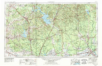
1954 Map of Beaumont
USGS Topo · Published 1979About this map
The Trinity River and Neches River systems anchor this regional landscape, which saw significant hydrological changes by the late 1970s. The presence of the massive Lake Livingston and Lake Conroe reservoirs highlights the mid-century transformation of the East Texas water basin, providing a distinct contrast to the dense woodlands of the Sam Houston National Forest and the diverse ecosystems of the Big Thicket National Preserve.
Find a feature on this map
124 named features on this map. Tap any name to fly to it.
Don’t see what you’re looking for? This feature index may not catch every label — zoom into the map to look around manually.
Map Details
Editions of this 1954 Beaumont Map
3 editions found

Other maps of this area

1914 · Navasota
USGS Topo · 1:62,500

1915 · Cypress
USGS Topo · 1:24,000

1916 · Rose Hill
USGS Topo · 1:24,000

1916 · Aldine
USGS Topo · 1:24,000

1916 · Crosby
USGS Topo · 1:24,000

1916 · Louetta
USGS Topo · 1:24,000

1916 · Harmaston
USGS Topo · 1:24,000

1916 · Moonshine Hill
USGS Topo · 1:24,000

1916 · Hockley
USGS Topo · 1:24,000

1916 · Satsuma
USGS Topo · 1:24,000