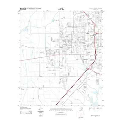
2013 Map of Beaumont West
USGS Topo · Published 2013About this map
Amelia Oil Field and the South China Oil Field anchor the industrial character of this Jefferson County landscape, where the subsurface extraction economy meets the residential expansion of West Beaumont. Subdivisions like Calder Highlands, Caldwood Acres, and Sunnyside demonstrate the 21st-century suburban footprint, while the West Beaumont Oil Field indicates the long-standing importance of petroleum to the local economy. The terrain is defined by a complex network of man-made and natural waterways, including the B1 Canal and Gallier Canal, which cross the prairie alongside Hillebrandt Bayou. Aviation and local history intersect at the Beaumont Municipal Airport, while the Hebert Cem offers a point of interest for genealogists tracing family ties in the Walden area. Drainage patterns like Jones Gully and Willow Marsh Bayou remain central to the geography of this low-lying coastal plain.
Find a feature on this map
249 named features on this map. Tap any name to fly to it.
Don’t see what you’re looking for? This feature index may not catch every label — zoom into the map to look around manually.
Map Details
Editions of this 2013 Beaumont West Map
This is the sole edition of this map. No revisions or reprints were ever made.
Other maps of this area

1926 · Lakeview
USGS Topo · 1:24,000

1926 · Vidor
USGS Topo · 1:24,000

1932 · Beaumont
USGS Topo · 1:62,500

1943 · Fannett East
USGS Topo · 1:24,000

1943 · Beaumont East
USGS Topo · 1:24,000

1945 · Fannett East
USGS Topo · 1:31,680

1950 · Houston
USGS Topo · 1:250,000

1954 · Beaumont
USGS Topo · 1:250,000

1955 · Sour Lake
USGS Topo · 1:62,500

1956 · Houston
USGS Topo · 1:250,000