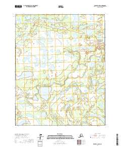
2017 Map of Beaver A-4 NW
USGS Topo · Published 2017About this map
Gushiate Lake and Fishnet Lake sit at the center of this wetland-rich interior Alaskan landscape, which is defined by an intricate network of slow-moving water and seasonal drainage. The area is part of a complex hydrologic system where E Fork the Forks meanders across the northern boundary, while Pat Creek and Meadow Creek weave through the southern reaches. This 2017 survey reveals the shifting nature of the Yukon-Koyukuk region, where geographic features like Gamble Slough and Mail Slough indicate a dynamic riparian environment. Remote and largely dominated by water bodies such as Minkoshchaliton Lake and Abraham Lake, the map provides a precise record of the land's natural contours and water distribution, essential for understanding the environmental patterns of this high-latitude terrain.
Find a feature on this map
16 named features on this map. Tap any name to fly to it.
Don’t see what you’re looking for? This feature index may not catch every label — zoom into the map to look around manually.
Map Details
Editions of this 2017 Beaver A-4 NW Map
This is the sole edition of this map. No revisions or reprints were ever made.
Other maps of this area

1951 · Beaver
USGS Topo · 1:250,000

1956 · Beaver A-5
USGS Topo · 1:63,360

1956 · Beaver B-5
USGS Topo · 1:63,360

1956 · Beaver
USGS Topo · 1:250,000

1956 · Beaver A-4
USGS Topo · 1:63,360

1956 · Beaver B-4
USGS Topo · 1:63,360

1964 · Beaver
USGS Topo · 1:250,000
2017 · Beaver A-5 SE
USGS Topo · 1:25,000
2017 · Beaver B-5 SE
USGS Topo · 1:25,000
2017 · Beaver A-5 NE
USGS Topo · 1:25,000