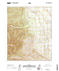
2017 Map of Beaver A-6 SE
USGS Topo · Published 2017About this map
Unsettled Alaskan wilderness within the Beaver A-6 SE quadrangle is defined by a dense network of wetlands and intricate hydrography. This 2017 study illustrates a landscape devoid of named settlements or roads, instead focusing on the natural topography of the T14n R10w and T14n R9w townships. The map is a study of water and relief, showing countless unnamed lakes and ponds characteristic of the Yukon-Koyukuk region. In the western portion, the terrain rises into significant elevations, contrasted by the lower, water-saturated ground to the east in T15n R9w. The absence of man-made features underscores the remote character of this interior Alaska territory, where the Public Land Survey System grid serves as the primary point of reference for researchers and surveyors.
Find a feature on this map
4 named features on this map. Tap any name to fly to it.
Don’t see what you’re looking for? This feature index may not catch every label — zoom into the map to look around manually.
Map Details
Editions of this 2017 Beaver A-6 SE Map
This is the sole edition of this map. No revisions or reprints were ever made.
Other maps of this area

1945 · Livengood
USGS Topo · 1:250,000

1951 · Livengood
USGS Topo · 1:250,000

1951 · Beaver
USGS Topo · 1:250,000

1952 · Livengood D-5
USGS Topo · 1:63,360

1956 · Beaver A-5
USGS Topo · 1:63,360

1956 · Beaver
USGS Topo · 1:250,000

1956 · Livengood D-6
USGS Topo · 1:63,360

1956 · Livengood
USGS Topo · 1:250,000

1964 · Beaver
USGS Topo · 1:250,000

1964 · Livengood
USGS Topo · 1:250,000