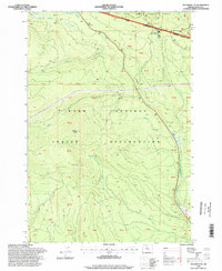
1996 Map of Beaver Butte
USGS Topo · Published 1998About this map
The National Indian Forest Boundary, established along the historic McQuinn Line, bisects this landscape as it appeared in the late 20th century. This boundary marks the northern edge of the Warm Springs Indian Reservation, separating it from the Mount Hood National Forest. The Bear Springs Ranger Station serves as a key administrative landmark in the northeast, situated near the headwaters of Indian Creek.
Find a feature on this map
39 named features on this map. Tap any name to fly to it.
Don’t see what you’re looking for? This feature index may not catch every label — zoom into the map to look around manually.
Map Details
Editions of this 1996 Beaver Butte Map
This is the sole edition of this map. No revisions or reprints were ever made.
Other maps of this area

1924 · Mount Hood
USGS Topo · 1:125,000

1927 · Mount Hood
USGS Topo · 1:125,000

1927 · Mt. Jefferson
USGS Topo · 1:125,000

1928 · Madras
USGS Topo · 1:125,000

1930 · Mt. Jefferson
USGS Topo · 1:125,000

1930 · Dufur
USGS Topo · 1:125,000

1931 · Madras
USGS Topo · 1:125,000

1934 · Dufur
USGS Topo · 1:125,000

1953 · The Dalles
USGS Topo · 1:250,000

1955 · Bend
USGS Topo · 1:250,000