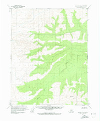
1970 Map of Beaver C-6
USGS Topo · Published 1973About this map
Hodzana River meanders across this interior landscape, defining the central drainage system of the region during the early 1970s. The terrain is dominated by the prominent elevation of Dall Mountain, which stands as a significant landmark in the southeast corner of the quadrangle. This 1:63,360 scale survey provides a detailed look at the unpeopled wilderness before modern development or infrastructure reached this portion of the Fairbanks Meridian. The Dall River also cuts through the southern reaches, highlighting the intricate network of waterways that governed travel and seasonal movement in this remote area. Prepared through photogrammetric methods from 1970 aerial photography, the map reflects a period of systematic federal documentation by the Bureau of Land Management and the U.S. Geological Survey to establish township and range lines in unsurveyed territory.
Find a feature on this map
3 named features on this map. Tap any name to fly to it.
Don’t see what you’re looking for? This feature index may not catch every label — zoom into the map to look around manually.
Map Details
Editions of this 1970 Beaver C-6 Map
This is the sole edition of this map. No revisions or reprints were ever made.
Other maps of this area

1951 · Bettles
USGS Topo · 1:250,000

1951 · Beaver
USGS Topo · 1:250,000

1956 · Bettles
USGS Topo · 1:250,000

1956 · Beaver B-5
USGS Topo · 1:63,360

1956 · Beaver
USGS Topo · 1:250,000

1964 · Beaver
USGS Topo · 1:250,000
1970 · Beaver D-5
USGS Topo · 1:63,360
1970 · Bettles D-1
USGS Topo · 1:63,360

1970 · Beaver B-6
USGS Topo · 1:63,360
1970 · Beaver C-5
USGS Topo · 1:63,360