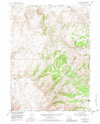
1953 Map of Beaver Creek
USGS Topo · Published 1983About this map
The Shirley Mountains dominate the landscape of Carbon County, Wyoming, in this mid-century survey that documents a transition between active ranching and the vast high-desert wilderness of the Shirley Basin. The mapping reveals the footprint of early livestock operations, specifically noting the sites of the Tikkinen Ranch (Aband) and Salmi Ranch (Aband). These locations, along with the Campbell Headquarters Camp, highlight the seasonal and permanent structures required for high-altitude grazing. Water management is a primary theme of the terrain, visible through features like the Cowden Reservoir and the network of drainages including Lost Creek and Norbacher Creek. The survey also tracks the industrial infrastructure of the era, such as a prominent Pipeline and the Shirley Basin Road, which provided essential access to this remote interior portion of the state.
Find a feature on this map
32 named features on this map. Tap any name to fly to it.
Don’t see what you’re looking for? This feature index may not catch every label — zoom into the map to look around manually.
Map Details
Editions of this 1953 Beaver Creek Map
3 editions found
Other maps of this area

1953 · Leo
USGS Topo · 1:24,000

1953 · Seminoe Dam NE
USGS Topo · 1:24,000

1953 · Seminoe Dam SE
USGS Topo · 1:24,000

1953 · Fourmile Point
USGS Topo · 1:24,000

1953 · Fourmile Ridge
USGS Topo · 1:24,000

1953 · Schneider Ridge
USGS Topo · 1:24,000

1953 · The Q Ranch
USGS Topo · 1:24,000

1953 · T E Ranch
USGS Topo · 1:24,000

1953 · Beaver Creek
USGS Topo · 1:24,000

1955 · Casper
USGS Topo · 1:250,000