1980 Map of Beaver Dam
USGS Topo · Published 1981About this map
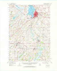
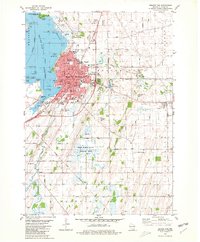
The city of Beaver Dam serves as the focal point of this 1980 survey, where the waters of Beaver Dam Lake meet the Beaver Dam River. The landscape reflects a well-established community with educational institutions like Wayland Academy and multiple neighborhood schools including Lincoln Sch and Jefferson Sch. The town's religious and civic fabric is visible through various churches and the Municipal Bldg. Outside the city center, the terrain transitions into the conservation lands of the Shaw Marsh State Wildlife Area, where Shaw Creek and Shaw Marsh define the drainage pattern. Further south, the map identifies the small settlement of Leipsig and its namesake Leipsig Cemetery, alongside several family and community burial grounds such as Clason Prairie Cemetery and Hyland Prairie Cemetery, providing vital records for local history and genealogy.
Find a feature on this map
77 named features on this map. Tap any name to fly to it.
Don’t see what you’re looking for? This feature index may not catch every label — zoom into the map to look around manually.
Map Details
Editions of this 1980 Beaver Dam Map
This is the sole edition of this map. No revisions or reprints were ever made.
Historical Maps of Beaver Dam Through Time
3 maps found