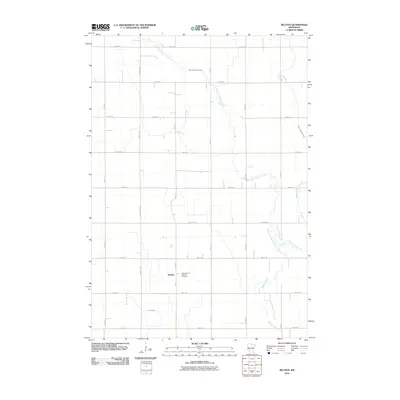
2010 Map of Bechyn
USGS Topo · Published 2010About this map
Bechyn serves as the quiet anchor of this rural Renville County landscape, situated near the intersection of County Hwy-1 and 730th Ave. This corner of Minnesota is defined by its rectilinear grid of section roads, including 280th St and 800th Ave, which carve the prairie into productive agricultural tracts. Waterways provide the primary break in this geometry, with the West Fork Beaver Creek and East Fork Beaver Creek meandering through the fields to converge into Beaver Creek in the south. Local history is physically preserved at Saint Mary's Bechyn Cemetery, while Smith Creek drains the southwestern portion of the map. The layout reflects a deeply established farming community where drainage and transport are the fundamental drivers of the landscape's organization.
Find a feature on this map
21 named features on this map. Tap any name to fly to it.
Don’t see what you’re looking for? This feature index may not catch every label — zoom into the map to look around manually.
Map Details
Editions of this 2010 Bechyn Map
This is the sole edition of this map. No revisions or reprints were ever made.
Other maps of this area

1952 · Morton
USGS Topo · 1:62,500

1952 · Redwood Falls
USGS Topo · 1:62,500

1953 · New Ulm
USGS Topo · 1:250,000

1957 · New Ulm
USGS Topo · 1:250,000

1957 · Olivia
USGS Topo · 1:62,500

1958 · New Ulm
USGS Topo · 1:250,000

1965 · Danube
USGS Topo · 1:24,000

1965 · Renville
USGS Topo · 1:24,000

1967 · New Ulm
USGS Topo · 1:250,000
1982 · Vicksburg
USGS Topo · 1:24,000