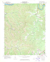
1969 Map of Beckwith
USGS Topo · Published 1972About this map
Beards Fork and the surrounding Fayette County landscape reveal an intensive industrial era dominated by coal and rail just before the 1970s. The terrain is deeply marked by numerous Strip Mine operations and individual Mine entries, connected by a network of Conveyor systems and rail lines including the Norfolk and Western and the Chesapeake and Ohio. Small mining settlements like Lochgelly, Summerlee, and Wriston sit along the creek beds, their social fabric anchored by landmarks such as Loop Creek Ch, Bethel Ch, and Doggett Chapel. In the northern corner, the topography shifts toward the dramatic confluence at the Kanawha River and New River, where Hawks Nest State Park provides a recreational contrast to the industrial character of nearby Deepwater and Charlton Heights. The map also captures mid-century cultural artifacts like the Harlem Heights Drive-in Theater and the 4-H Camp near Beckwith.
Find a feature on this map
70 named features on this map. Tap any name to fly to it.
Don’t see what you’re looking for? This feature index may not catch every label — zoom into the map to look around manually.
Map Details
Editions of this 1969 Beckwith Map
2 editions found
Other maps of this area

1891 · Raleigh
USGS Topo · 1:125,000

1897 · Kanawha Falls
USGS Topo · 1:125,000

1897 · Raleigh
USGS Topo · 1:125,000

1900 · Kanawha Falls
USGS Topo · 1:125,000

1901 · Kanawha Falls
USGS Topo · 1:125,000

1902 · Raleigh
USGS Topo · 1:125,000

1908 · Fayetteville
USGS Topo · 1:48,000

1908 · Montgomery
USGS Topo · 1:48,000

1910 · Fayetteville
USGS Topo · 1:62,500

1910 · Montgomery
USGS Topo · 1:62,500