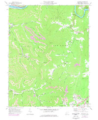
1969 Map of Beckwith
USGS Topo · Published 1977About this map
Kanawha River and New River corridors anchor this 1969 West Virginia landscape, where the rugged topography of the New Haven district is deeply marked by the region's industrial heritage. The convergence of the Chesapeake and Ohio and Norfolk and Western railroads highlights the vital transport network serving the numerous valley settlements. While the northern edge features Charlton Heights and the heights of Hawks Nest State Park, the interior reveals an intensive pattern of coal extraction. Extensive strip mines contour around Ford Knob and the Valley area, showing the direct impact of mining on the local geography. Scattered communities such as Beards Fork, Lochgelly, and Beckwith are connected by winding roads and proximity to mountain streams like Loop Creek and Wolf Creek. This survey captures a moment when traditional valley life, represented by Doggett Chapel and the Beckwith Sch, coexisted with the expanding footprint of the energy industry.
Find a feature on this map
69 named features on this map. Tap any name to fly to it.
Don’t see what you’re looking for? This feature index may not catch every label — zoom into the map to look around manually.
Map Details
Editions of this 1969 Beckwith Map
2 editions found
Other maps of this area

1891 · Raleigh
USGS Topo · 1:125,000

1897 · Kanawha Falls
USGS Topo · 1:125,000

1897 · Raleigh
USGS Topo · 1:125,000

1900 · Kanawha Falls
USGS Topo · 1:125,000

1901 · Kanawha Falls
USGS Topo · 1:125,000

1902 · Raleigh
USGS Topo · 1:125,000

1908 · Fayetteville
USGS Topo · 1:48,000

1908 · Montgomery
USGS Topo · 1:48,000

1910 · Fayetteville
USGS Topo · 1:62,500

1910 · Montgomery
USGS Topo · 1:62,500