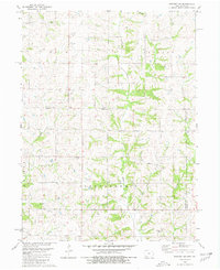
1980 Map of Bedford SW
USGS Topo · Published 1981About this map
The undulating terrain of the Iowa-Missouri borderlands defines this 1980 survey, where rural life is anchored by family-named landmarks and country congregations. Settlers and their descendants established numerous burial grounds across these townships, including the Township Cem and Forest Grove Cem in the north, while the Berea Ch stands as a focal point for the Ross community. The landscape is deeply dissected by a network of waterways like Honey Creek and Mozingo Creek, which dictate the placement of roads and farmsteads. These drainage patterns influenced the jurisdictional boundaries where Taylor Co, Nodaway Co, and Worth Co meet at the state line. Genealogists will find particular value in the distribution of smaller family and community plots such as Kemery Cem, New Hope Cem, and Luteston Cem, which remain as persistent markers of nineteenth-century settlement patterns amidst the active agricultural fields of the late twentieth century.
Find a feature on this map
20 named features on this map. Tap any name to fly to it.
Don’t see what you’re looking for? This feature index may not catch every label — zoom into the map to look around manually.
Map Details
Editions of this 1980 Bedford SW Map
This is the sole edition of this map. No revisions or reprints were ever made.
Other maps of this area

1940 · Bedford
USGS Topo · 1:62,500

1940 · New Market
USGS Topo · 1:62,500

1940 · Parnell
USGS Topo · 1:62,500

1943 · Bedford
USGS Topo · 1:62,500

1943 · Parnell
USGS Topo · 1:62,500

1943 · Maryville
USGS Topo · 1:62,500

1943 · New Market
USGS Topo · 1:62,500

1955 · Nebraska City
USGS Topo · 1:250,000

1957 · Nebraska City
USGS Topo · 1:250,000

1958 · Nebraska City
USGS Topo · 1:250,000