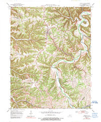
1953 Map of Bedford
USGS Topo · Published 1989About this map
Bedford serves as the central hub for this portion of Trimble County, situated within a landscape defined by the winding course of the Little Kentucky River. This 1950s era documentation reflects a rural agricultural community connected by a network of ridges and hollows, where local landmarks like Hickory Grove Ch and Antioch Ch mark the social centers of the countryside. The southern edge of the map identifies the path of the Louisville and Nashville railroad, highlighting the critical transportation corridor that linked these upland settlements to larger regional markets. Numerous small drainages such as Barebone Creek, Sweetwater Branch, and Demeree Branch carve through the terrain, illustrating the intricate watershed that feeds into the river. For those tracing family history, the distribution of small settlements like Browning and Morton provides a detailed look at the post-war spatial arrangement of this Kentucky river valley.
Find a feature on this map
28 named features on this map. Tap any name to fly to it.
Don’t see what you’re looking for? This feature index may not catch every label — zoom into the map to look around manually.
Map Details
Editions of this 1953 Bedford Map
3 editions found

Other maps of this area

1928 · New Castle
USGS Topo · 1:48,000

1932 · New Castle
USGS Topo · 1:62,500

1932 · La Grange
USGS Topo · 1:62,500

1939 · Bethlehem
USGS Topo · 1:24,000

1939 · Madison West
USGS Topo · 1:24,000

1943 · Brooksburg
USGS Topo · 1:24,000

1948 · Bethlehem
USGS Topo · 1:24,000

1948 · Madison West
USGS Topo · 1:24,000

1952 · Campbellsburg
USGS Topo · 1:24,000

1953 · Madison West
USGS Topo · 1:24,000