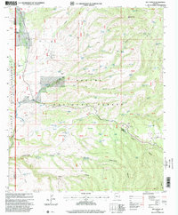
1997 Map of Bee Canyon
USGS Topo · Published 2000About this map
Double Circle Ranch and the N O Bar Ranch anchor this landscape along the border of Graham and Greenlee counties. The terrain is defined by a dense network of high-desert water management features, including dozens of stock tanks such as Coyote Tank, Bear Tank, and Gibson Tank, which supported the region's ranching economy. Cattle operations are further evidenced by numerous structures like the Loading Corral and various unnamed Corral sites scattered through the canyons.
Find a feature on this map
83 named features on this map. Tap any name to fly to it.
Don’t see what you’re looking for? This feature index may not catch every label — zoom into the map to look around manually.
Map Details
Editions of this 1997 Bee Canyon Map
This is the sole edition of this map. No revisions or reprints were ever made.
Other maps of this area

1902 · Clifton
USGS Topo · 1:62,500

1913 · Morenci
USGS Topo · 1:125,000

1915 · Morenci
USGS Topo · 1:125,000

1954 · Clifton
USGS Topo · 1:250,000

1957 · Clifton
USGS Topo · 1:250,000

1958 · Clifton
USGS Topo · 1:250,000

1962 · Clifton
USGS Topo · 1:250,000

1962 · Clifton
USGS Topo · 1:62,500

1962 · Bryce Mountain
USGS Topo · 1:62,500

1967 · Robinson Mesa
USGS Topo · 1:24,000