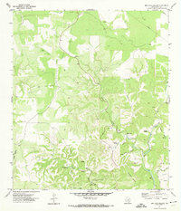
1971 Map of Bee Cave Hollow
USGS Topo · Published 1974About this map
Prade Ranch sits at the heart of this limestone-carved landscape in Real County, where the Short Prong and West Frio River cut deep through the Balcones Escarpment. The 1970s survey reveals a territory defined by intricate drainage networks, from Bee Cave Hollow to the broad Anvil Hollow, highlighting the vital importance of water sources like Bee Cave Spring, Miller Springs, and Mingus Spring for local ranching.
Find a feature on this map
26 named features on this map. Tap any name to fly to it.
Don’t see what you’re looking for? This feature index may not catch every label — zoom into the map to look around manually.
Map Details
Editions of this 1971 Bee Cave Hollow Map
2 editions found
Other maps of this area

1954 · Llano
USGS Topo · 1:250,000

1954 · San Antonio
USGS Topo · 1:250,000

1955 · Llano
USGS Topo · 1:250,000

1956 · Llano
USGS Topo · 1:250,000

1957 · San Antonio
USGS Topo · 1:250,000

1963 · Garven Store
USGS Topo · 1:24,000

1964 · Hillcrest Ranch
USGS Topo · 1:24,000

1964 · Circle Bluff
USGS Topo · 1:24,000
1971 · Earwood Creek
USGS Topo · 1:24,000
1971 · Owl Hollow
USGS Topo · 1:24,000