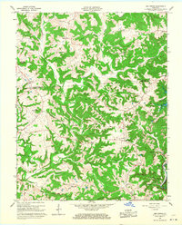
1966 Map of Bee Spring
USGS Topo · Published 1968About this map
Bee Spring and the surrounding timbered ridges of the Grayson and Edmonson County border define this mid-1960s landscape. This era marks a significant shift for the region as the Nolin Reservoir begins to take shape, with the map recording the controlled inundation areas along the Nolin River. Smaller settlements like Sadler, Sweeden, and Sunfish remain centered around rural infrastructure, including South Union Ch and St Johns Sch.
Find a feature on this map
49 named features on this map. Tap any name to fly to it.
Don’t see what you’re looking for? This feature index may not catch every label — zoom into the map to look around manually.
Map Details
Editions of this 1966 Bee Spring Map
2 editions found
Other maps of this area

1922 · Leitchfield
USGS Topo · 1:48,000

1922 · Brownsville
USGS Topo · 1:62,500

1922 · Mammoth Cave
USGS Topo · 1:62,500

1923 · Mammoth Cave
USGS Topo · 1:62,500

1923 · Brownsville
USGS Topo · 1:62,500

1925 · Cub Run
USGS Topo · 1:62,500

1925 · Leitchfield
USGS Topo · 1:62,500

1953 · Ready
USGS Topo · 1:24,000

1953 · Bee Spring
USGS Topo · 1:24,000

1954 · Evansville
USGS Topo · 1:250,000