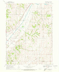
1970 Map of Beebeetown
USGS Topo · Published 1972About this map
Boyer River drainage patterns define this landscape on the border of Harrison and Pottawattamie Counties, where the alluvial plain meets the loess hills of western Iowa. The transportation corridor is anchored by the parallel tracks of the Chicago and North Western and Illinois Central railroads, which bypass the smaller upland settlements in favor of the river valley. While Beebeetown sits as a primary inland hub, the map reveals the remnants of smaller rail-side points like Euclid and Findley. Genealogists will find significant local history in the rural burial grounds, including Frazier Cem, Oak Grove Cem, and Linwood Cem. The presence of the Logan-Missouri Valley Country Club and a Gaging Station along the river reflect the mid-century development of the region's recreational and agricultural infrastructure.
Find a feature on this map
21 named features on this map. Tap any name to fly to it.
Don’t see what you’re looking for? This feature index may not catch every label — zoom into the map to look around manually.
Map Details
Editions of this 1970 Beebeetown Map
This is the sole edition of this map. No revisions or reprints were ever made.
Other maps of this area

1893 · Omaha
USGS Topo · 1:62,500

1954 · Omaha
USGS Topo · 1:250,000

1956 · Underwood
USGS Topo · 1:24,000

1957 · Omaha
USGS Topo · 1:250,000

1957 · Loveland
USGS Topo · 1:24,000

1957 · Honey Creek
USGS Topo · 1:24,000

1958 · Omaha
USGS Topo · 1:250,000

1970 · Logan
USGS Topo · 1:24,000
1970 · Missouri Valley
USGS Topo · 1:24,000
1970 · Missouri Valley NW
USGS Topo · 1:24,000