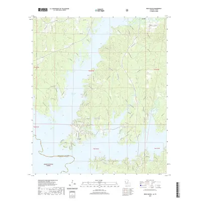
2020 Map of Beech Bayou
USGS Topo · Published 2020About this map
Toledo Bend Reservoir dominates the western landscape of this Sabine Parish region, its flooded fingers reaching deep into the timbered hills of the Sabine National Forest. The geography is defined by a series of drainages including Beech Bayou, Little Beech Bayou, and Bayou Scie that feed the massive reservoir along the Louisiana and Texas border. Near the northern edge, the town of Zwolle serves as a local hub, while the presence of the Old Saint Joseph Cem provides a specific point of interest for those tracing family history in the area. The map illustrates a complex network of forest and residential roads such as Garcie Rd and Carters Ferry Rd, reflecting the area's development around the water and its proximity to Ammons Airport. This contemporary survey details how modern infrastructure and the managed waters of the reservoir have shaped the older bayou terrain.
Find a feature on this map
100 named features on this map. Tap any name to fly to it.
Don’t see what you’re looking for? This feature index may not catch every label — zoom into the map to look around manually.
Map Details
Editions of this 2020 Beech Bayou Map
This is the sole edition of this map. No revisions or reprints were ever made.
Other maps of this area

1941 · Zwolle
USGS Topo · 1:62,500

1944 · Negreet
USGS Topo · 1:62,500

1944 · Patroon
USGS Topo · 1:62,500

1944 · Zwolle
USGS Topo · 1:62,500

1953 · Alexandria
USGS Topo · 1:250,000
1954 · Negreet
USGS Topo · 1:24,000

1954 · Negreet
USGS Topo · 1:62,500

1954 · Salter Creek
USGS Topo · 1:24,000

1955 · Alexandria
USGS Topo · 1:250,000

1956 · Patroon
USGS Topo · 1:62,500