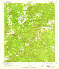
1954 Map of Negreet
USGS Topo · Published 1958About this map
The settlement of Negreet anchors this mid-century survey of Sabine Parish, revealing a rural landscape defined by Spanish colonial land history and a network of small creeks. Large tracts of the La Nana Grant dominate the northern portion of the map, a remnant of historic land claims that contrast with the standard section lines found elsewhere. The terrain is deeply carved by waterways such as Negreet Creek, Turner Creek, and Bayou Negreet, which dictated the placement of early homesteads and community hubs. Social life in this period centered on dispersed country churches and burial grounds, including Zion Hill Church, Redland Church, and Antioch Church. The Doss Fire Lookout Tower stands as a prominent landmark overlooking the pine-heavy hills, while small family or community plots like Roberts Cemetery and Doss Cemetery provide specific points of interest for genealogical research.
Find a feature on this map
18 named features on this map. Tap any name to fly to it.
Don’t see what you’re looking for? This feature index may not catch every label — zoom into the map to look around manually.
Map Details
Editions of this 1954 Negreet Map
Other maps of this area

1941 · Zwolle
USGS Topo · 1:62,500

1942 · Many
USGS Topo · 1:62,500

1942 · Florien
USGS Topo · 1:62,500

1943 · Many
USGS Topo · 1:62,500

1944 · Negreet
USGS Topo · 1:62,500

1944 · Florien
USGS Topo · 1:62,500

1944 · Zwolle
USGS Topo · 1:62,500

1953 · Alexandria
USGS Topo · 1:250,000

1954 · Toro
USGS Topo · 1:24,000

1954 · Columbus
USGS Topo · 1:24,000