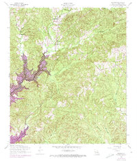
1954 Map of Negreet
USGS Topo · Published 1973About this map
Negreet and the surrounding piney woods of Sabine Parish appear here during a transformative era for western Louisiana. A significant portion of the landscape is defined by the Toledo Bend Reservoir, which flooded former bottomlands along Negreet Creek and its tributaries. While the western edge is dominated by this massive water project, the interior remains a network of rural communities such as Dess and Palo. Genealogists will find many local landmarks preserved, from Zion Hill Church to the Roberts Cemetery and Dess Cemetery. The map also delineates the extensive boundaries of the La Nana Grant, a reminder of the region's colonial land-tenure history that persisted alongside modern infrastructure like the Dess Fire Lookout Tower.
Find a feature on this map
19 named features on this map. Tap any name to fly to it.
Don’t see what you’re looking for? This feature index may not catch every label — zoom into the map to look around manually.
Map Details
Editions of this 1954 Negreet Map
Other maps of this area

1941 · Zwolle
USGS Topo · 1:62,500

1942 · Many
USGS Topo · 1:62,500

1942 · Florien
USGS Topo · 1:62,500

1943 · Many
USGS Topo · 1:62,500

1944 · Negreet
USGS Topo · 1:62,500

1944 · Florien
USGS Topo · 1:62,500

1944 · Zwolle
USGS Topo · 1:62,500

1953 · Alexandria
USGS Topo · 1:250,000

1954 · Toro
USGS Topo · 1:24,000

1954 · Columbus
USGS Topo · 1:24,000