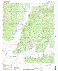
1984 Map of Beech Bayou
USGS Topo · Published 1984About this map
The boundary between Louisiana and Texas is defined here by the course of the Sabine River, a landscape transformed by the waters of the Toledo Bend Reservoir. This survey shows the region as it appeared in the early 1980s, dominated by the heavily wooded terrain of the Sabine National Forest. The settlement of Alliance stands as the primary community hub, situated amidst a dense network of waterways including Beech Bayou, Hurricane Creek, and Spring Branch. The map captures the intricate shoreline of the reservoir, where flooded creek beds create long, finger-like inlets such as Bayou San Miguel and La Nana Bayou. The geography reflects a transition from traditional riverine bottomlands to a modern managed reservoir system, serving as an essential record for those studying the parish's evolving water table and land use after the damming of the river.
Find a feature on this map
13 named features on this map. Tap any name to fly to it.
Don’t see what you’re looking for? This feature index may not catch every label — zoom into the map to look around manually.
Map Details
Editions of this 1984 Beech Bayou Map
This is the sole edition of this map. No revisions or reprints were ever made.
Other maps of this area

1941 · Zwolle
USGS Topo · 1:62,500

1944 · Negreet
USGS Topo · 1:62,500

1944 · Patroon
USGS Topo · 1:62,500

1944 · Zwolle
USGS Topo · 1:62,500

1953 · Alexandria
USGS Topo · 1:250,000
1954 · Negreet
USGS Topo · 1:24,000

1954 · Negreet
USGS Topo · 1:62,500

1954 · Salter Creek
USGS Topo · 1:24,000

1955 · Alexandria
USGS Topo · 1:250,000

1956 · Patroon
USGS Topo · 1:62,500