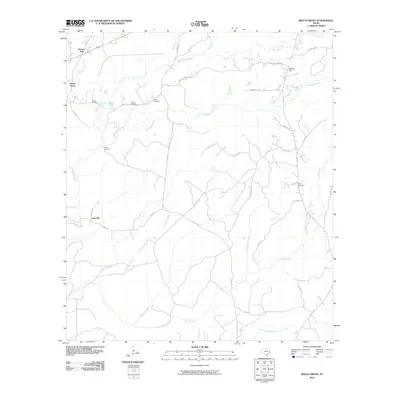
2010 Map of Beech Grove
USGS Topo · Published 2010About this map
Beech Grove and several small rural settlements characterize this Jasper County landscape as it appeared in the early 21st century. The map reveals a high density of family-named burial grounds, such as Holton Cemetery, Sanders Cemetery, and Allen Cemetery, which provide essential clues for genealogists tracking local lineages in East Texas. The terrain is defined by a dense network of tributaries including Big Walnut Run, Little Walnut Run, and Pickering Creek that flow toward the larger Big Creek in the south. The distribution of small communities like Science Hall in the northwest and Spring Hill in the northeast, connected by routes such as FM 777 and FM 252, suggests a long-standing pattern of dispersed timber and agricultural residences. Notable landmarks like Oak Hill and the Dunn Cemetery further anchor the geographic history of this region near the Louisiana border.
Find a feature on this map
46 named features on this map. Tap any name to fly to it.
Don’t see what you’re looking for? This feature index may not catch every label — zoom into the map to look around manually.
Map Details
Editions of this 2010 Beech Grove Map
This is the sole edition of this map. No revisions or reprints were ever made.
Other maps of this area

1952 · Lake Charles
USGS Topo · 1:250,000

1954 · Lake Charles
USGS Topo · 1:250,000

1954 · Beaumont
USGS Topo · 1:250,000

1955 · Roganville
USGS Topo · 1:62,500

1955 · Curtis
USGS Topo · 1:62,500

1957 · Beaumont
USGS Topo · 1:250,000

1958 · Spurger
USGS Topo · 1:62,500

1958 · Kirbyville
USGS Topo · 1:62,500

1984 · Beaumont
USGS Topo · 1:250,000
1984 · Roganville
USGS Topo · 1:24,000