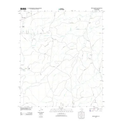
2013 Map of Beech Grove
USGS Topo · Published 2013About this map
Beech Grove and the surrounding rural landscape of Jasper County are defined by a complex network of small cemeteries and winding creek branches. This territory, situated between the older settlements of Science Hall and Spring Hill, is marked by a history of family-centered burials and small-scale timber or agricultural access roads. The geography is dominated by numerous watercourses including Big Walnut Run, Pickering Cr, and Big Cr, which carve through the terrain and influence the placement of early homesteads.
Find a feature on this map
69 named features on this map. Tap any name to fly to it.
Don’t see what you’re looking for? This feature index may not catch every label — zoom into the map to look around manually.
Map Details
Editions of this 2013 Beech Grove Map
This is the sole edition of this map. No revisions or reprints were ever made.
Other maps of this area

1952 · Lake Charles
USGS Topo · 1:250,000

1954 · Lake Charles
USGS Topo · 1:250,000

1954 · Beaumont
USGS Topo · 1:250,000

1955 · Roganville
USGS Topo · 1:62,500

1955 · Curtis
USGS Topo · 1:62,500

1957 · Beaumont
USGS Topo · 1:250,000

1958 · Spurger
USGS Topo · 1:62,500

1958 · Kirbyville
USGS Topo · 1:62,500

1984 · Beaumont
USGS Topo · 1:250,000
1984 · Roganville
USGS Topo · 1:24,000