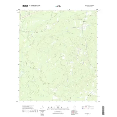
2019 Map of Beech Grove
USGS Topo · Published 2019About this map
Sanders Cem and Allen Cem sit atop the ridges of Jasper County, marking family histories in this densely wooded landscape of East Texas. The terrain is defined by a complex network of drainage, where Big Walnut Run and Little Walnut Run carve through the northern hills. Further south, the map reveals the winding courses of Pickering Cr and Big Cr, illustrating the heavy riparian influence on local land use and road placement. Settlement is concentrated near Spring Hill, with a web of county roads like Oak Hill Cemetary Rd connecting scattered homesteads and small family burial grounds. The transition from upland ridges to the wet bottoms of Hurricane Br and Walker Br demonstrates the traditional rural layout of the region, where roads navigate between the numerous creek branches and cemetery sites.
Find a feature on this map
60 named features on this map. Tap any name to fly to it.
Don’t see what you’re looking for? This feature index may not catch every label — zoom into the map to look around manually.
Map Details
Editions of this 2019 Beech Grove Map
This is the sole edition of this map. No revisions or reprints were ever made.
Other maps of this area

1952 · Lake Charles
USGS Topo · 1:250,000

1954 · Lake Charles
USGS Topo · 1:250,000

1954 · Beaumont
USGS Topo · 1:250,000

1955 · Roganville
USGS Topo · 1:62,500

1955 · Curtis
USGS Topo · 1:62,500

1957 · Beaumont
USGS Topo · 1:250,000

1958 · Spurger
USGS Topo · 1:62,500

1958 · Kirbyville
USGS Topo · 1:62,500

1984 · Beaumont
USGS Topo · 1:250,000
1984 · Roganville
USGS Topo · 1:24,000