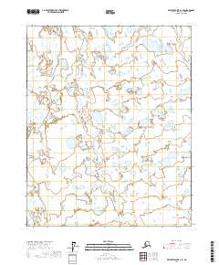
2017 Map of Beechey Point A-1 SE
USGS Topo · Published 2017About this map
Shaviovik River and the Kavik River wind through this remote segment of the North Slope, revealing a landscape defined by braided waterways and extensive wetlands. Surveyed in 2017, the map illustrates the intricate drainage patterns of the Arctic coastal plain, where the rivers meander across a flat expanse of tundra. The absence of roads or established settlements emphasizes the wilderness character of the region, which is organized primarily by the Public Land Survey System boundaries of t9n r19e, t9n r20e, t8n r19e, and t8n r20e. Researchers interested in the hydrology of Northern Alaska can trace the shifting channels and numerous small lakes that dot the terrain between these two significant watercourses.
Find a feature on this map
6 named features on this map. Tap any name to fly to it.
Don’t see what you’re looking for? This feature index may not catch every label — zoom into the map to look around manually.
Map Details
Editions of this 2017 Beechey Point A-1 SE Map
This is the sole edition of this map. No revisions or reprints were ever made.
Other maps of this area

1951 · Beechey Point
USGS Topo · 1:250,000

1951 · Sagavanirktok D-5
USGS Topo · 1:250,000

1951 · Mt. Michelson
USGS Topo · 1:250,000

1955 · Flaxman Island
USGS Topo · 1:250,000

1955 · Beechey Point
USGS Topo · 1:250,000

1955 · Mount Michelson D-5
USGS Topo · 1:63,360

1955 · Flaxman Island A-5
USGS Topo · 1:63,360

1955 · Beechey Point A-1
USGS Topo · 1:63,360
1955 · Sagavanirktok D-1
USGS Topo · 1:63,360

1956 · Mt. Michelson
USGS Topo · 1:250,000