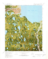
1970 Map of Beechey Point A-2 NE
USGS Topo · Published 1971About this map
Sagavanirktok River Delta dominates the northwestern corner of this 1970 orthophotomap, showing the intricate braided channels and alluvial deposits where the river meets the Beaufort Sea. The landscape is a complex mosaic of thermokarst lakes and tundra wetlands, characteristic of the North Slope coastal plain. To the northeast, the waters of Foggy Island Bay open up, separated from the mainland by the low-lying Foggy Island. This survey, prepared from aerial photography, captures the stark geography of the region just as the industrial era of the North Slope was beginning to take shape. The map uses gray land lines provided by the Bureau of Land Management to indicate unsurveyed and unmarked locations, emphasizing the remote and largely undeveloped nature of the terrain at this moment in history.
Find a feature on this map
5 named features on this map. Tap any name to fly to it.
Don’t see what you’re looking for? This feature index may not catch every label — zoom into the map to look around manually.
Map Details
Editions of this 1970 Beechey Point A-2 NE Map
2 editions found
Other maps of this area

1951 · Beechey Point
USGS Topo · 1:250,000

1955 · Beechey Point
USGS Topo · 1:250,000

1955 · Beechey Point B-2
USGS Topo · 1:63,360

1955 · Beechey Point B-1
USGS Topo · 1:63,360

1955 · Beechey Point A-1
USGS Topo · 1:63,360

1955 · Beechey Point A-2
USGS Topo · 1:63,360

1960 · Beechey Point
USGS Topo · 1:250,000
1962 · Beechey Point A-1
USGS Topo · 1:50,000

1962 · Beechey Point B-2
USGS Topo · 1:50,000
1962 · Beechey Point B-1
USGS Topo · 1:50,000