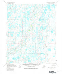
1955 Map of Beechey Point A-4
USGS Topo · Published 1981About this map
The Kuparuk River carves a braided path through this Arctic coastal plain as it was documented in 1955. The landscape is a dense network of thaw lakes and ponds characteristic of the North Slope, with the meandering Putuligayuk River and the Sakonowyak River further defining the drainage patterns. While no permanent settlements or roads appear at this date, several named points including Eileen, Hurl, Neal, and Hemi indicate early survey markers or temporary camps within the tundra. These labels provide a window into the initial mapping efforts in an area that would later become central to Alaskas energy industry. The presence of several Well labels suggests early exploration activities already underway in the mid-century, long before the establishment of modern infrastructure.
Find a feature on this map
15 named features on this map. Tap any name to fly to it.
Don’t see what you’re looking for? This feature index may not catch every label — zoom into the map to look around manually.
Map Details
Editions of this 1955 Beechey Point A-4 Map
3 editions found
Other maps of this area

1951 · Beechey Point
USGS Topo · 1:250,000

1951 · Sagavanirktok D-5
USGS Topo · 1:250,000

1955 · Beechey Point
USGS Topo · 1:250,000

1955 · Beechey Point B-4
USGS Topo · 1:63,360

1955 · Beechey Point A-5
USGS Topo · 1:63,360

1955 · Beechey Point A-3
USGS Topo · 1:63,360

1955 · Beechey Point A-4
USGS Topo · 1:63,360

1955 · Beechey Point B-5
USGS Topo · 1:63,360

1955 · Beechey Point B-3
USGS Topo · 1:63,360

1955 · Sagavanirktok D-3
USGS Topo · 1:63,360