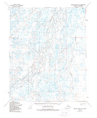
1955 Map of Beechey Point A-4
USGS Topo · Published 1988About this map
The Kuparuk River winds through this expanse of Alaska’s North Slope, a landscape defined by intricate braided channels and seasonal transport routes. This 1955 survey captures the region just as petroleum exploration began to mark the tundra with early industrial infrastructure, including an Oil Well and a Drill Hole. The presence of the Winter Trail highlights the seasonal nature of Arctic travel, while smaller named points such as Neal, Lou, and Polka serve as critical landmarks in a terrain otherwise dominated by the Putuligayuk River and Sakonowyak River. This map provides a technical view of the North Slope Borough before the full-scale development of the Prudhoe Bay oil fields, documenting the earliest physical interventions in the remote wilderness.
Find a feature on this map
12 named features on this map. Tap any name to fly to it.
Don’t see what you’re looking for? This feature index may not catch every label — zoom into the map to look around manually.
Map Details
Editions of this 1955 Beechey Point A-4 Map
3 editions found
Other maps of this area

1951 · Beechey Point
USGS Topo · 1:250,000

1951 · Sagavanirktok D-5
USGS Topo · 1:250,000

1955 · Beechey Point
USGS Topo · 1:250,000

1955 · Beechey Point B-4
USGS Topo · 1:63,360

1955 · Beechey Point A-5
USGS Topo · 1:63,360

1955 · Beechey Point A-3
USGS Topo · 1:63,360

1955 · Beechey Point A-4
USGS Topo · 1:63,360

1955 · Beechey Point B-5
USGS Topo · 1:63,360

1955 · Beechey Point B-3
USGS Topo · 1:63,360

1955 · Sagavanirktok D-3
USGS Topo · 1:63,360